Slieve Commedagh – the forgotten Mourne mountain
Slieve Commedagh – the forgotten Mourne mountain
30 November 2022
SLIEVE Commedagh is the forgotten mountain of the Mournes. It is a comparatively unknown summit despite being one of the peaks that forms the iconic Mourne panorama, frequently featured in local folklore, and even used in Hollywood blockbusters like King Arthur.
At 767 metres, only the neighbouring Slieve Donard (850m) is higher. Yet Donard overshadows its sibling in other ways too.
On any given weekend, streams of walkers ascend the Glen River Valley from Newcastle, meeting the Mourne Wall at the ‘Saddle’ — the col between Donard and Commedagh. There, they have a decision to make. Turn left and you scale Donard. Turn right and you climb Commedagh.
Most choose Donard, despite it being somewhat of a dead end. Being at the seaboard side of the Mournes means that most people reach Donard’s summit and simply descend the same way. Whereas if you choose Slieve Commedagh, you open a gateway to the rest of the Mournes.
From Commedagh’s summit, you can walk westwards along a ridge that undulates over Slieve Corragh and Slievenaglogh until you reach Hare’s Gap and Slieve Bearnagh. That ridge provides unrivalled views of Strangford Lough, the Ards Peninsula and even Harland and Wolff’s yellow cranes in Belfast.
Pivoting south, you can scan the length of the Annalong Valley and the sequence of Slieve Beg, Cove Mountain, Slievelamagan and Slieve Binnian.
Slieve Beg, meaning ‘the little mountain’, is where to find the Devil’s Coachroad. Locals believed that this steep gorge was where the Devil used to come up from the underworld.
Slieve Commedagh, previously known as Kiviter, means ‘Mountain of Watching’ because its summit provides commanding 360 degree views. It is where local clans used to watch for attacks on their land below. The ‘Meadow Mountain’ is another nickname because of its grassy, rounded summit. Yet this nonde dome should not deceive anyone into thinking that Commedagh is devoid of geological treasures.
It has two corries on its eastern and west shoulders — a corrie being a steep-sided, bowl-shaped hollow at the head of a valley. On the east is the Pot of Pulgarve, which you pass as you climb the Glen River Valley. On Commedagh’s western shoulder is the Pot of Legawherry. This is where the Spinkwee River starts, before flowing into Tollymore Forest and joining the Shimna and Trassey Rivers to flow into the Irish Sea.
The Pot of Legawherry is also where the remains of multiple booley huts are found. These were the ancient stone houses that cattle herders migrated to in summer, to graze their cattle on the uplands. In the ‘Official Guide to County Down and the Mourne Mountains’ (1900), the naturalist Robert Lloyd Praeger wrote that:
“The Pot of Legawherry, one of the most picturesque in Mourne, at the head of the Spinkwee River, is a deep depression surrounded on three sides by cliffs and pinnacles of granite.”
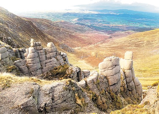
The “pinnacles of granite” are the reward you receive for choosing to climb Commedagh. These spectacular stone stacks are found where the Pot of Legawherry joins Commedagh’s western slope. Nicknamed ‘Commedagh’s chimneys’, they also unlock the secrets of how the Mournes were made.
Being among Ireland’s youngest mountains, the Mournes used to be just a wide plateau. Successive ice ages then carved, cut, and smoothed the landscape – largely thanks to a Scottish ice sheet streaming southwards across eastern Ireland and then an Irish ice sheet crashing into it as it made its own south-eastern advance from Donegal.
Over millions of years, this battle between ice sheets sculpted the Irish Sea — and the Mourne landscape. Associated erosion turned fissures into fractures, gullies into gorges and cracks into corries. It chiselled the iconic outline of the Mournes that is instantly recognisable today.
Some summits were smoothed into domes. In other areas, erosion stripped away the top layer of soft shale rock to unearth the granite magma that had previously been forced up through the shale rock and had then cooled and hardened. Removal of the shale left only the tougher towers of granite behind — those like Commedagh’s chimneys.
Similar monuments are seen on the other side of the mountain too. Commedagh’s south-facing slope has a larger expanse of stone stacks that resemble the ruins of a gothic castle. They are known as the Fairy Castles of Commedagh, or, in local folklore, Kathleen’s Castle.
The story is that Kathleen was a beautiful young woman from a local clan who used Commedagh to watch over their herds. When her family arranged a marriage for her, with a man she had never met, when she refused and was banished to live in a cave on Commedagh’s southern slope, facing the Annalong Valley.
One day Kathleen met a fairy near her new home. He was distressed after tearing his coat on some granite — and feared that no fairy woman would ever marry him. Kathleen promised to help and sewed him a brand new coat. The fairy was so thankful that he vowed to return the favour one day.
Years later, Kathleen bumped into the fairy and his new wife by a lough at the other end of the Annalong Valley. This time it was Kathleen who was unhappy, believing she would die as a cave-dwelling spinster.
The fairy knew it was time to return the favour. He raced across Antrim, Donegal and Down to round up his fellow fairies. They came en masse to the Mournes with all their tools, soon transforming Kathleen’s cave into a magnificent castle.
It wasn’t long before it caught the eye of a handsome passer-by. He fell in love with Kathleen and they spent the rest of their days together. Legend has it that, in a twist of fate, he was also the man who Kathleen’s family originally chose for her to marry.
Folklore or not, a chance to see Kathleen’s Castle is another reason to think twice about tackling Slieve Donard, and instead consider the lesser-trodden path up Slieve Commedagh — the forgotten mountain of the Mournes.


- Follow us on:
